


October of this year resembled summer due to high temperatures, but November is ready to show its “menacing grin” from the very beginning, since in the next few days real autumn will come in most areas and everything that comes with it: colder temperatures and rains.
Forecasters are warning of a sudden change in the weather from Thursday (2/11), while the worst weather will hit most parts of the country over the weekend. Cyclone “P”, as meteorologists called it, will bring with it weather disasters.
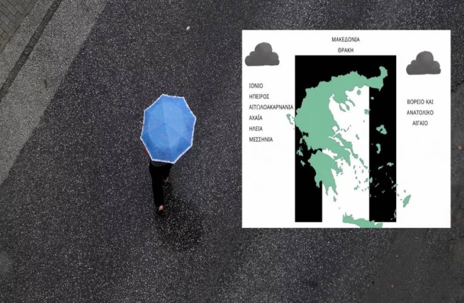
Weather2go.gr and Alpha TV meteorologist Georgios Tsatrafillias, in a post on his personal Facebook account, presents an image to inform citizens about what exactly is the bad weather “P” that will hit Greece this weekend (4-5/11).
According to the picture below, bad weather will hit the country in a U shape, affecting the following regions: Macedonia, Thrace, Ionian Sea, Epirus, Aetolocarnania, Achaia, Elis, Messinia, North and East Aegean Sea.
Weekend weather according to EMY:
Saturday (04/11) pIncreased cloudiness with rain and thunderstorms is forecast for almost the entire country. Consequences that are likely to occur locally strong, will initially appear in the north-west, but will quickly spread to all western, central and northern parts of Greece, and gradually affect the rest of the country from midday.
Intense events are expected to be limited to the Aegean Sea and Thrace from late evening. The wind is southerly, 5-6 points, in the Aegean Sea in places from 7 to 8 points on the Beaufort scale. From midday in the Ionian Sea region and the western continental part of the country (and in the afternoon in the rest of Greece), with the exception of Thrace, the wind will change its direction to the west. The air temperature will drop by 4°C from the maximum set values in previous days.
On Sunday (05/11) at Aegean Sea and Thrace until morning cloudy, rain and thunderstorms (locally intense manifestations of bad weather). The weather will become generally clear in most areas, with rain expected only on the Dodecanese Islands before midday.
In western Greece, slightly locally increased cloudiness and light rain are expected from midday. Storms are possible in the northwest. The rest of the country has mostly clear weather with occasional local cloudiness. Wind from west/southwest from 4 to 6 on the Beaufort scale. In the Aegean Sea region, air temperatures will drop significantly.
More Stories
Showers and storms throughout Greece
Hurricane with rain and hail hits Thessaloniki (video)
Wild boars are on the loose in Nafpaktia