


According to meteorologists, cyclone Elias will hit the capital region of Attica on Wednesday, September 27. However, since Monday, thunderstorms and downpours brought by the cyclone have created numerous problems in Achaia and unfortunate Thessaly.
Cyclone Elias
Since yesterday evening, the movement of the cyclone Elias has continued, which has already hit Epirus and Achaea with heavy rains, thunderstorms and hail in places, creating a threat to western Thessaly. Tomorrow, cyclone Elias, according to experts, will become even more active and will hit the Attica basin in the morning with intense weather phenomena.
In addition, tomorrow, according to experts, the weather phenomenon will reach its peak and gradually its intensity will begin to decrease on Thursday, when it will begin to decline.
According to the forecast meteo.gr/EAA, local and periodically strong phenomena are expected until the end of Tuesday in the Ionian, Western and Central parts of Central Greece, the Peloponnese and, secondarily, in Thessaly and Epirus. In some areas these events will be accompanied by hail, mainly in Western Greece and the central Ionian Islands.
The most affected areas until the evening of Tuesday 26/09, where the most rainfall will occur, will be located in the prefectures of Kefalonia, Lefkada, Aitoloakarnania, Evrytania, Phocis, Phthiotis, Ilia, Achaia, Corinthia, and from late evening in Karditsa and Trikala.
The forecast map below shows the expected geographical distribution of total rainfall (in millimetres) until the end of Tuesday 26/09. Darker shades indicate the highest precipitation levels.

Worsening weather on Wednesday
On Wednesday 27/09 the phenomena will intensify even more and will affect the central, eastern and southern regions of the country to a greater extent. The most intense weather events are expected in Eastern and Southern Thessaly, Evia, the Sporades, Central and Eastern Sterea and the Peloponnese – especially in the central and northern parts, where the most rainfall is likely to occur. Areas that will be affected include the prefecture of Attica and the city of Athens. Showers and thunderstorms will also occur on several island parts of the Aegean Sea and on Crete, and in the prefecture of Chania they will be intense.
The synoptic map below shows the approximate geographical distribution of total rainfall (in millimetres) until the end of Wednesday 27/09. Deeper shades indicate the highest precipitation amounts.

Roads in Trikala flooded again, major damage in Achaia, problems in Epirus
Cyclone Elias arrived in Achaia yesterday with heavy hail in the mountains and beyond. This caused problems on a section of the Patras-Athens highway, at the height of Agialea.
https://rua.gr/news/prireco/57887-tsiklon-elias-uzhe-v-gretsii.html
Due to landslides, traffic on the road to Athens was interrupted. For some time it was restored one lane at a time when Olympia Odos equipment managed to clear part of the roadway, but then it was interrupted again. This is due to the fact that the volume of water drained from the mountain is very large, and as a result, drainage canals, despite their large size, in many places do not have time to absorb it, which leads to floods.
Shortly before midnight, after a break caused by mudflows, traffic towards Athens was allowed to move on two-way traffic in the opposite direction, from the Elaion toll station at km 163.5 to km 160.6.
Σε κυκλοφορία το ρεύμα προς Αθήνα μέσω αμφιδρόμησης στο αντίθετο ρεύμα, από το Σταθμό Διοδίων Ελαιώνα στο 163,5χλμ. έως το 160,6χλμ.
Παρακαλούνται οι οδηγοί να διέρχονται με προσοχή, με χαμηλές ταχύτητες και να συμμορφώνονται με την οδική σήμανση.
— Olympia Odos (@OlympiaOdosSA) September 25, 2023
Trikala floods again
— Zougla.gr (@zougla_online) September 26, 2023
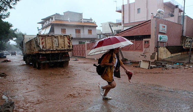
A few days after the devastating cyclone Daniel passed through Thessaly, cyclone Elias swept through the country. As photographs and videos show, in Trikala there are many problems with streets that have turned into rivers under the influence of collapsing water. According to trikaladay.gr, in the mountainous areas of the municipalities of Pili and Meteora, the torment of the authorities continues, as many rock and soil collapses have occurred there. The rains caused problems in the prefecture’s mountainous road network due to landslides, Trikala deputy head Christos Michalakis told local media. In contrast, in low-lying areas of the prefecture, river levels are within normal limits and there have been no major problems so far, with the exception of some flooded roads and basements.
#Κακοκαιρία Elias: Πλημμύρισαν δρόμοι στα Τρίκαλα – Ζημιές και στην Αχαΐα (βίντεο) https://t.co/3clF7NQgZN
— Proson.gr (@proson_gr) September 26, 2023
The good news is that it doesn’t rain all the time.
Τώρα είδε όλος ο κόσμος το πόσο έξυπνη πόλη είμαστε!https://t.co/vo4yH4QyY3
— 🧭leonidas tsioumas (@leon_tsioumas) September 25, 2023
Indicative is the video from Kalambaki street, which in the first hour of the Elias storm in Trikala turned… into a river. According to trikalavoice.gr, the road was filled with water for the third time in the last 4 months, leaving drivers stranded as they sought detours.
More Stories
D. Sariyannis: “We expect African dust in mid-May”
Dust from the Sahara: first results of analysis of chemical components
Lyrid meteor shower, make a wish on a shooting star