If you thought the days of extreme hot weather were over, you are sadly wrong. Temperatures dropped slightly after 43 degrees on Friday and Saturday, but a new wave of hot weather will begin from Thursday, which may be even more intense.
Windy weather will prevail until Thursday, according to weather forecasts, which will slightly reduce the temperature and reduce stuffiness, although the temperature will remain high, reaching 40 ° C in places. However, on Thursday, according to meteorologist Panagiotis Giannopoulos, and at least until Sunday, the temperature in the entire continental part of Greece will exceed 40°C, and in some areas it will reach 43°C. At the same time, as noted, the second heat wave will have not only duration, but also intensity, perhaps somewhat greater than last Friday and Saturday.
MEGA meteorologist Yiannis Kallianos noted in a Facebook post that the entire month of July is likely to be very hot. “Looking at the big picture, from Thursday 20/7 until at least Sunday 23/7 the temperature at an altitude of 1500 meters above Attica will be about 26-27 ° C. On average at this time of the year to extrapolate to calculate the temperature at zero altitude, we add 15-16°C. Therefore, starting next Thursday 20/7, and then and especially from next Friday 21/7, we expect temperatures of 42-43°C,” he said.
https://www.facebook.com/ioannis.kallianos/posts/6538091362919446
Warning from Kolidas
Meteorologist Theodoros Kolidas warns of a new wave of heat that will cover Greece from Thursday.
“High anticyclone values in the European south and strong heat transfer to lower levels, especially on Friday and next weekend, will lead to a long period. From next Monday, some decrease in temperature is expected from the north,” the report says.
Οι Υψηλές οι τιμές του αντικυκλωνα στον Ευρωπαϊκό Νότο και η έντονη θερμή μεταφορά στις κατωτερες στάθμες, ιδιαιτερα την Παρασκευή και το προσεχές Σαββατοκυριακο, θα οδηγήσουν σε μεγάλη διάρκεια της ζέστης. Από ερχόμενη Δευτέρα και από τα Βόρεια διαφαίνεται υποχωρηση. pic.twitter.com/zSnlYpqfME
— Theodoros Kolydas (@KolydasT) July 17, 2023
New heat wave from Thursday
According to an updated special report by EMY, in Thursday July 20, maximum temperatures will reach 40-42°C on the mainland, 43°C locally, 39-41°C on the Ionian Islands and 36-38°C on the islands of the Aegean Sea. The meteorogram, posted on Sunday at noon by Sakis Arnautoglu, shows how temperatures are rising day by day. However, he explains that “for a fairly accurate calculation of the temperature in the area of interest to you, please carefully read the explanations to the meteorogram, because, as it is natural, depending on the area, altitude and proximity to the sea, the temperature will differ!!!”
https://www.facebook.com/SakisArnaoutoglouForecasts/posts/827664115389951
Heat and stuffiness at night
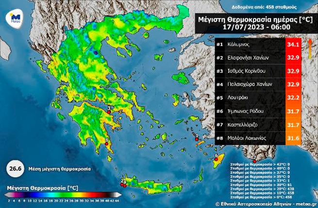
Despite the drop in temperature since Saturday, the night from Sunday 16/07 to Monday 17/07 was especially warm. It is impressive that by 06:00 am, 61 stations of the network of automatic weather stations of the National Observatory of Athens / Meteo.gr recorded temperatures above 30 degrees Celsius. The map below shows the 8 stations that recorded the highest temperatures until 06:00 am.


More Stories
A 3.5 meter long shark was spotted in the port of Volos
Weather forecast: rain and storms in Athens and Thessaloniki on Saturday
Easter with… umbrellas: unstable weather in the coming days – where will it rain