The bad weather that has hit Greece since Sunday evening continues. According to the EMY emergency bulletin, since early morning heavy rain and thunderstorms have hit central Macedonia, Thessaly (mainly in the east), eastern Sterea (including Attica), the Cyclades, Crete (mainly in the south), the Peloponnese, locally Euboea and the Sporades. A gradual weakening of the phenomena is expected from the second half of the day.
From noon, the islands of the eastern Aegean Sea (from Chios and further south) and the Dodecanese will be affected by bad weather.
“Showers and thunderstorms in the Cyclades, Dodecanese and Crete will be locally heavy and likely to be accompanied by significant rainfall and hail.”
On Tuesday, intense phenomena will persist in the southern regions of the Dodecanese and gradually weaken by midday.
Heavy precipitation
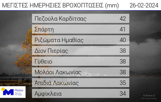
According to the network of automatic weather stations meteo.gr/National Observatory of Athens, from midnight Sunday 25/02 to 08:00 Monday 26/02, showers and thunderstorms with significant precipitation occurred in continental areas.

The table shows the 8 highest precipitation values.
In Attica, intense phenomena will continue until the evening
Regarding the development of bad weather for the rest of Monday 26/02, showers and thunderstorms are expected mainly in Central and Western Macedonia, Thessaly, Central and Eastern Sterea, Peloponnese, Central and Southern Aegean. In Attica, the phenomena are expected to continue, but will weaken significantly from the afternoon, reports meteo.gr. It is noted that:
- Showers and thunderstorms in the Cyclades, Dodecanese and Crete will be locally heavy and likely to be accompanied by significant rainfall and hail.
- The transfer of Saharan dust will cause mud showers in some places.
- Southern winds, reaching 7-8 points on the Beaufort scale in the central and southern seas, will gradually weaken in some places from midday and will not exceed 6-7 points.
- These phenomena are expected to gradually weaken from Monday afternoon, except in the Cyclades, Crete and Dodecanese, where they will remain intense.
According to the precipitation classification (regional precipitation index) applied by the meteorological department of the National Observatory of Athens, the current precipitation falls into category 3 (significant).


More Stories
Weather: hot and windy weekend
Blue Flag: 22 Greek beaches stripped of honorary label
What Are Cruise Ships Worth for the Planet (Video)