


Meteorologist Yiannis Kallianos said the weather will change over the next few days, with precipitation falling mainly in the west and north of Greece.
The meteorologist stressed that weather conditions will be more intense from Friday afternoon to Saturday afternoon. “This is a cyclone that will move from west to east across the country,” – he said. “There will be rain in Attica on Friday evening, but it doesn't look like it will cause any problems.” – he added.
“From Thessaloniki and further east, up to Alexandroupoli, the likelihood of flooding increases, as the events will be intense and prolonged,” – he emphasized. According to Yiannis Kallianos, during these 24 hours (Friday – Saturday noon) the eastern Aegean islands of Lemnos, Chios, Lesbos, Samos and Ikaria will experience large amounts of rainfall.
More details about Thursday's weather according to EMY
Localized rain in the west, north and eastern islands, mainly isolated thunderstorms in the northeast in the morning hours. The rest of the country has almost clear weather with few clouds, mainly during the midday and afternoon hours.
The concentration of African dust will gradually decrease in the east. The wind will blow from the west, in the Ionian Sea up to 5, and in the Aegean Sea locally up to 7 on the Beaufort scale. Temperatures will drop mainly in the north and will range from 21 to 23°C in most areas.
Forecast for Friday (19/4)
Initially cloudy in the west, center and north, with localized showers and occasional thunderstorms. From midday these phenomena will spread to the rest of the country, with the exception of eastern Crete and the Dodecanese. Light snow will fall in the northern and central highlands of the country.
The wind will blow from the west: first from the southwest from 4 to 6 points on the Beaufort scale, and from the second half of the day – from the west/northwest to 7 points. In the Aegean Sea, the wind will blow from the southern directions from 5 to 7 points, and in the northern part of the Aegean Sea in the evening hours – from the northern directions from 5 to 7 points and locally in the northwestern part of the Aegean Sea up to 8 points. Temperatures will cool in the west, center and north, ranging from 18 to 20°C in the west, 16 to 18°C in the northeast and 19 to 22°C in the rest of the mainland and island country.
Forecast for Saturday (20/4)
In the north, in Thessaly and the eastern parts of the country it will be cloudy, with showers and thunderstorms, possibly heavy. Gradually the phenomena will weaken. The rest of the country will be cloudy with scattered showers and possibly isolated thunderstorms, improving quickly, except in Macedonia and the northern Ionian Sea. Snowfall will occur in the northern and central highlands of the country.
Winds will be from the west/northwest at 5 to 7 and locally at sea at 8 Beaufort, easing temporarily in the evening. Temperatures will drop slightly further to minimum values.
Forecast for Sunday (21/4)
Cloudy in Macedonia and the west, with scattered showers and possibly isolated thunderstorms. A gradual increase in cloudiness is expected across the rest of the continent, with isolated thundershowers possible during the midday and afternoon hours, mainly in the mountains. The rest of the country will be partly cloudy.
Light snow will occur in the mountainous areas of the northwestern and northern parts of the country. The wind will blow from south-westerly directions, in the west from 4 to 6, and in the Aegean Sea from 5 to 7, with a gradual weakening in the afternoon. The air temperature will rise slightly.
More Stories
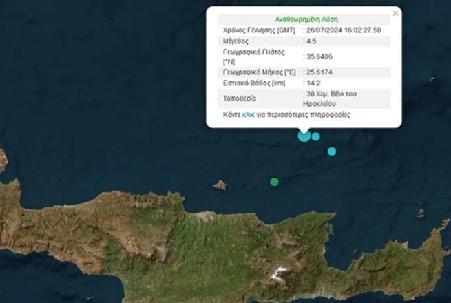
Earthquake in Crete with magnitude 4.5 on the Richter scale
Weather: hot and windy weekend
Blue Flag: 22 Greek beaches stripped of honorary label