


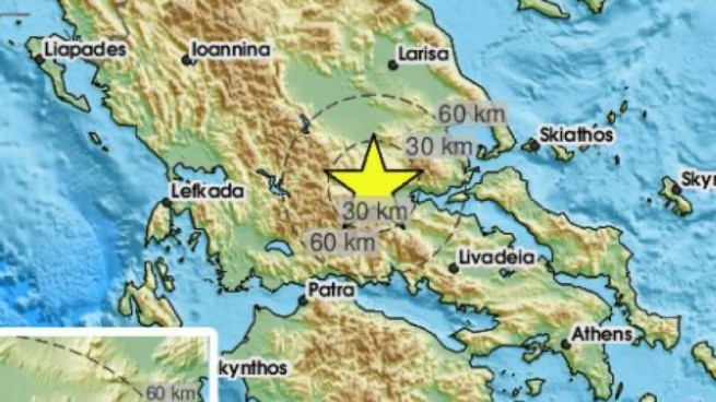
An earthquake measuring 4.0 on the Richter scale occurred in Lamia, in the Loutra Ipatis region, and was felt over a wider area.
According to the Athens Geodynamic Institute, the epicenter of the earthquake was 9 km east of Sperchiada, and the depth of the source is estimated at 13.5 km. According to APE, no damage from the earthquake has been recorded.
🔔#Earthquake (#σεισμός) M4.0 occurred 14 km W of #Lamía (#Greece) 3 min ago (local time 11:13:38). More info at:
📱https://t.co/bvL9EDQjKG
🌐https://t.co/y8wqMprHGL
🖥https://t.co/kGp5gxZPio pic.twitter.com/mojhuedhjh— EMSC (@LastQuake) October 22, 2023
Based on the earthquake registration regulation (from 2000), the regions of Greece are assessed from from the point of view of seismic hazard in four categories, starting with the last – “D” zone, exposed to the highest risk of seismic activity, and ending with the “A” zone, which includes the “least dangerous” areas in terms of earthquakes.
There is a lot of talk about Greece’s earthquake susceptibility. Although no one can still say exactly when an earthquake will occur, where, with what focal depth and what catastrophes it can bring.
The recent earthquake shows two things. Firstly, the European continent in terms of the frequency of seismic hazards is incomparable with Japan, or, say, with Chile, but in hour X The shaking here can be no less. And secondly, the level of infrastructure development in Europe is so high that even a not very strong earthquake can cause severe consequences. Tremors of 7-8 points on the Richter scale somewhere in the Andes or the Pamirs (where you cannot find a human soul for thousands of kilometers) are comparable in the consequences of destruction in Greece, for example, with tremors of 5-6 points (in a densely populated area).
Scientists regularly conduct studies in which they try to determine the most dangerous, “red” zones. A previous study published by the Earthquake Protection and Prevention Organization (ΟΑΣΠ) identified ten main parameters that affect the strength of structures, such as shape, height, building area and construction conditions. At the same time, seismologists, of course, continue to try to detect “signs” of an impending disaster. WITHseismic hazard of the regions:
Zone D (the most dangerous)
- Argostoli, (Kefalonia),
- Sami, Kefalonia,
- Zakynthos,
- Ithaca,
- Lefkada.
Zone C (less dangerous than D)
- Egeo,
- Atalanti,
- Hair,
- Igoumenitsa,
- Heraklion,
- Thebes,
- Corinth,
- Kythira,
- Kos,
- Lamia,
- Larisa,
- Livadia,
- Mytilene,
- Nafpaktos,
- Patras,
- Preveza,
- Pyrgos,
- Rethymno,
- Rhodes,
- Samos,
- Kalavrita,
- Kalamata,
- Karditsa,
- Karpathos,
- Corfu,
- Kilkis,
- Farsala,
- Chalkis,
- Chania,
- Chios.
Zone B (medium danger)
- Athens,
- Agrinio,
- Arta,
- Grevena,
- Drama,
- Thessaloniki,
- Santorini,
- Ioannina,
- Kavala,
- Komotini,
- Messolonghi,
- Metsovo,
- Nafplio,
- Xanthi,
- Kalambaka,
- Karpenisi,
- Kozani,
- Skyros,
- Sparta,
- Trikala.
Zone A (almost safe)
- Alexandroupolis,
- Andros,
- Veria,
- Yannitsa,
- Didimoticho,
- Edessa,
- Ermoupolis (Syros),
- Thassos,
- Kimi,
- Lavrio,
- Milos,
- Naoussa,
- Orestiada,
- Paros,
- Ptolemais,
- Serres,
- Karystos,
- Kastoria,
- Katerini,
- Florina.
More Stories
Thodoris Kolidas explains the phenomenon "black sky" on Good Friday
Black swan in the Evros river delta
The weather will turn bad on Good Friday