


Digital map showing all active fault lines in Greece and their characteristic features are now available to the public.
The map was prepared over the last two years by the Hellenic Directorate of Geological and Mineral Exploration (EAGME) based on data obtained from the Geodynamic Institute, the Universities of Athens, the Aristotle University of Thessaloniki and Patras and the National Research Institute for Geosciences and Natural Resources under the supervision/coordination of OASP (Organization for Earthquake Planning and Protection).
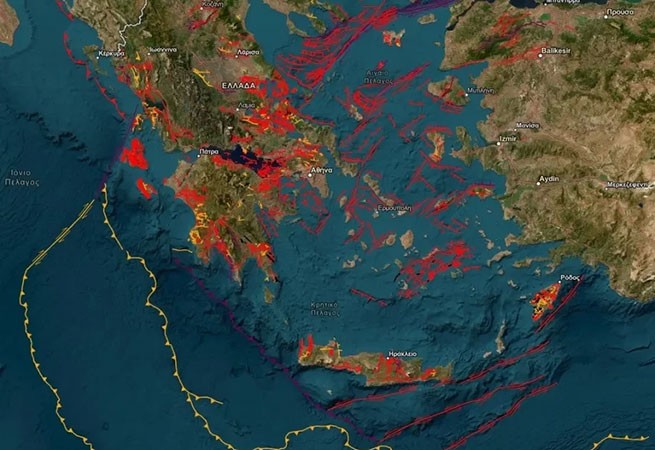
According to available data, the map currently shows 5500 properties in GreeceHowever, “this number does not coincide with the number of faults, since, for example, a fault 40,000 km long may have 10 records.” On the map, fault lines are marked in red, yellow and purple:
- purple the so-called are designated “seismic faults”that is, those that have been proven to be associated with one or more earthquakes in the instrumental or historical period (these are the most “dangerous”),
- red – “active faults”that is, those that have been displaced at least once during the Upper Pleistocene (the last 126,000 years or so) and therefore could be a source of future earthquakes>
- Yellow indicates “potentially active faults”those that resemble active faults in their characteristics (they were active at least once during the Quaternary period, over the last 2,600,000 years).
“To date, systematic work has been carried out and several active faults have been discovered” says Kostas Papazachos, professor at the Department of Lithospheric Physics, Seismology and Applied Geophysics at the Aristotle University of Thessaloniki. – OASP has taken the initiative to systematize this knowledge and develop it. This database is the first attempt to map what we know and what we don’t know.”.
The map will be dynamic, constantly updated and supplemented. However, it will not only be used by seismologists: “It is very important that the database is accessed by civil engineers, urban planners, municipalities, who need this information for all kinds of research. It is impossible to place a risky project on an active fault, that is, on a fault that has given or may give earthquakes in the near future. If, for example, a landfill is placed on such a site, this will be bad practice, since there is a risk of destruction of the layer preventing the penetration of waste into deeper soil layers. Similarly, it is impossible to build a hospital there. The database is certainly useful for developing seismic policy.
Despite constant research, many of the active faults are still unknown. The large faults are there (on the map). But the small ones, especially in the marine area, are a problem because many of them do not reach the surface. The marine area is very difficult to survey. There are areas with huge gaps, and unfortunately, because of the crisis, the scientists who could study all this have left Greece.”
The map is on the website activefaults.eagme.gr And Here
More Stories
Water Spout in Halkidiki
Supreme Court calls for "vigilance" in relation to those who "uses water illegally"
Destructive weather hits Meteora: floods, rockfalls, landslides