


The weather will change significantly today, Tuesday 7/03. Heavy rains are expected in the west of Greece, snow will fall in the mountains.
According to the forecast from the National Observatory of Athens/meteo.gr, rain is expected in the Ionian Islands, the western part of the mainland, the Peloponnese, the islands of the eastern Aegean, as well as in the rest of the mainland and from the daytime hours in the Cyclades and Crete.
The phenomena will be locally intense and accompanied by storms, mainly in the west of the country and the Peloponnese. Minor hail possible in the southern Ionian region. Snow will fall in the northwest in the mountains.
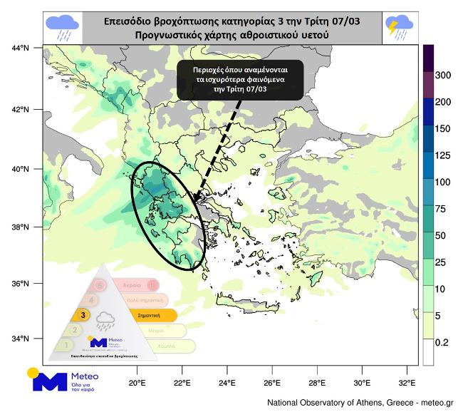
The forecast map below shows the estimated total rainfall for the day.
According to the classification of precipitation (RPI), which is carried out by the meteorological division of the National Observatory of Athens, their volume is classified as category 3 (significant).
EMY Forecast for Tuesday March 7th in Detail
Partly cloudy with occasional showers expected today. Sporadic storms will pass in the west, south and in the evening on the islands of the eastern Aegean. The manifestation of bad weather in the west is likely to be locally strong. Snowfall is expected in mountainous regions in the northwest of the country. Wind southwest from 4 to 6 on the Beaufort scale. The air temperature will not noticeably change. +15-16°С is expected in the north of the country, +17-18°С in other regions.
ATTICA
Weather: Partly cloudy with a chance of rain in the afternoon.
Wind: West/Southwest 3 to 4, from noon 5 to 6 Beaufort.
Air temperature: from +10°С to +18°С.
THESSALONIKI
Weather: Partly cloudy, which will gradually increase, in some places it will rain.
Wind: 3 to 4 on the Beaufort scale.
Air temperature: from +07°С to +16°С.
More Stories
Thodoris Kolidas explains the phenomenon "black sky" on Good Friday
Black swan in the Evros river delta
The weather will turn bad on Good Friday