

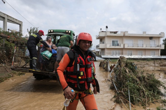
Greece’s National Meteorological Service (EMY) issued a RED ALERT weather warning on Tuesday as it predicts Cyclone Ariel will hit the country tonight, bringing heavy rains and powerful thunderstorms with high lightning frequency, especially in coastal areas.
A southerly gale force of 7-8 on the Beaufort scale is expected. Cyclone Ariel, whose epicenter is currently located off the coast of Sicily, will slowly move to the northeast and by the night of November 30 will hit the western coast of Greece. Then, moving to the northeast, it will pass through the entire Greek mainland, the islands of the central and northern Aegean Sea, and leave the country late on Thursday evening, December 1.
It is noted that the most intense weather events are expected in central and eastern Greece, Macedonia and in the northernmost parts of Thessaly. According to forecast data from the National Observatory of Athens/ meteo.gra precipitation episode (RPI) is classified as category 4 (very dangerous).
The main signs of the Ariel cyclone will be heavy rains and thunderstorms, which will be accompanied by hail, increased electrical activity and very strong gusty winds. At the same time, heavy snow is expected in the mountainous regions of central and northern Greece.
Weather forecast from November 30 to December 1, 2022:
- From Tuesday night hours (29-11-2022) to Thursday afternoon (01-12-2022): heavy rains and storms in the southern Ionian Sea, western and southern Peloponnese and western Crete.
- From Wednesday morning (30-11-2022) to Thursday afternoon (01-12-2022) the northern part of the Ionian Sea, western Sterea, Epirus, Crete – mainly west and southwest will be affected. Gradually also the rest of the Peloponnese, eastern Greece (including Attica), central Macedonia, Thessaly, the Cyclades, Evia and the Sporades.
- From noon environments (30-11-2022) till evening Thursday (1-12-2022) eastern Macedonia, the islands of the northern and eastern Aegean and the Dodecanese will be affected. From Thursday afternoon (01-12-2022) until the evening, Thrace will also be affected.
- Starting at noon Thursday (01-11-2022) Intense weather events will show gradual fading in most areas, but heavy rains and storms will continue into the evening on the islands of the Eastern Aegean and Dodecanese.
Temperature during the day 11-15°C, at night from 9°C to 12°C.
Citizens are asked to be especially careful
The General Secretariat for Civil Protection recommends that citizens take extra care to take measures to protect themselves against the risks posed by severe weather events.
In areas where heavy rainfall, storms or gale-force winds are expected:
- Secure items that could cause damage or injury if blown away in inclement weather.
- Make sure the gutters and downpipes are not blocked and are working properly.
- Do not cross streams and streams, on foot or by car, during thunderstorms and rain, and also for several hours after their end.
- Avoid working outdoors and operating in sea and coastal areas during adverse weather conditions (danger of lightning strikes).
- Take cover immediately during hail. Take shelter in a building or car and do not leave the safe area until you are sure the storm has passed. Hail can be very dangerous for animals too.
- Avoid walking under large trees, under posted signs, and in public areas where light objects (pots, broken glass, etc.) can break off and fall to the ground (for example, under balconies).
- Conscientiously follow the instructions of local authorities, traffic, etc.
In areas with intense thunderstorm activity
If you are at home:
- Do not hold on to electrical appliances or the telephone, as lightning can travel through the wires. Disconnect TVs from antenna and power supply.
- Do not touch plumbing pipes (kitchen, bathroom) as they are good conductors of electricity.
If you are in a car:
- Park it on the side of the road and away from trees that might fall on it.
- Stay inside and turn on your brake lights (emergency lights) until the storm subsides.
- Close windows and do not touch metal objects.
- Avoid flooded roads.
If you are on the street
- Take cover in a building or car, or immediately sit on the ground without lying down.
- If you are in a forest, take cover under the hard branches of low trees.
- Never take cover under a tall tree in an open area.
- Avoid lowlands due to the risk of flooding.
- Stay away from power poles and power lines, telephone lines and fences.
- Stay away from metal objects (eg cars, bicycles, camping equipment, etc.).
- Stay away from rivers, lakes and other bodies of water.
- If you are at sea, leave immediately.
- If you are isolated on a flat surface and feel like your hair is standing on end (signaling that lightning is about to strike), sit deep with your head between your legs (to minimize body surface area and contact with the ground), throw away metal objects, which you have.
Citizens can keep abreast of developments every day extreme weather events in regular EMY weather reports and on the EMY website at the online address www.emy.gr
For information and announcements about the current situation and the patency of the road network, due to the influx of flood waters, citizens can visit the site EL.AS. www.astynomia.gr
For more information and weather protection instructions citizens can visit the website of the General Secretariat for Civil Protection at www.civilprotection.gr
More Stories
African dust: another high in Greece on Tuesday
Heavy hail hits Halkidiki
Winter in the middle of summer: snow fell in the mountainous regions of Greece