


From Tuesday 23 to Friday 26 August, a sharp deterioration in the weather is predicted with heavy rains and thunderstorms, which will be accompanied by a high frequency of lightning, hail, and sharp gusts of wind.
Phenomena will also appear during the hours outside the classical weather instability (noon) and affect not only the mainland, but also the islands, especially the Aegean, Sporades, north Evia, north Aegean, mainly on Wednesday and Thursday.
More:
- Today (08/22/2022): in Macedonia and gradually in Thessaly, Sporades and Evia, a temporary increase in cloudiness is expected with local rain and thunderstorms. During the noon and afternoon hours, the phenomena will spread to the eastern mainland, the highlands of Epirus, western Sterea and Crete. By evening, the phenomena will be limited to eastern Macedonia. The rest of the country has generally clear weather.
The wind will be west/northwest from 3 to 4, in the Ionian Sea and in Crete in places 5 on the Beaufort scale. The temperature will drop a little more, and its maximum value will reach 31-33°C.
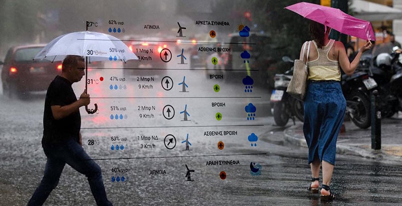
Partly cloudy will gradually increase, with local showers or scattered thunderstorms, mainly in the west and north, during the noon and afternoon hours.
Winds: 2 to 4 on the Beaufort scale.
Temperature: 23 to 33°C.
- Tomorrow Tuesday (23.08.2022) intermittent heavy rains and thunderstorms are predicted in central and eastern Macedonia, Thrace, Thessaly, eastern Sterea, Sporades, Evia, the islands of the northern Aegean Sea, and in the afternoon – in the rest of the mainland and Crete.
- Wednesday (August 24, 2022) bad weather will continue, affecting the eastern mainland and islands (except Dodecanese) from early morning and the rest of the mainland in the afternoon.
- Thursday (25-08-2022) heavy rains and storms are predicted in central and eastern Macedonia, Thrace, Thessaly, eastern Sterea, Sporades, Evia, the islands of the northeast Aegean, in the afternoon in the rest of the mainland and in Crete.
- Friday (26.08.2022)According to currently available forecast data, phenomena in the above areas will continue, but will gradually weaken. Autumn weather from today and throughout the week is gradually approaching across the country, which is a rare occurrence in August.
An atmospheric disturbance located to the northwest of our country over the wider Adriatic region is expected to cause widespread atmospheric instability on the second day with rain and storms over a large part, mainly in the central and northern parts of the country.
ΑΣΤΑΘΕΙΑ ΣΗΜΕΡΑ , ΚΥΡΙΩΣ ΚΕΝΤΡΙΚΑ ΚΑΙ ΒΟΡΕΙΑ
Οι περιοχές με τι, Πιθανόν ισχυρά τα φαινόμενα στη Μακεδονία.https://t.co/Gy8J0KaBJe pic.twitter.com/rLOS1KEbqW— Theodoros Kolydas (@KolydasT) August 22, 2022
Σε λίγο #έκτακτο από Τρίτη-Παρασκευή με τα φαινόμενα να εκδηλώνονται και σε ώρες εκτός της κλασικής αστάθειας, επηρεάζοντας και τη νησιωτική χώρα και κυρίως το Αιγαίο. Mεγαλύτερα ύψη βροχής σε Θεσσαλία, βόρεια Εύβοια, βόρειο Αιγαίο και Χαλκιδική @GSCP_GR @EMY_HNMS pic.twitter.com/KKit1cUlCW
— Theodoros Kolydas (@KolydasT) August 22, 2022
The cyclone that caused the bad weather belongs to the 2nd category according to the regional precipitation index (RPI) developed and operationally applied at the National Observatory of Athens/meteo.gr.
More Stories
Residents of 5 regions of Greece received "a storm warning"
Dolphins appeared in Thermaikos this morning
Most polluted countries in 2023: Greek regions with worst air quality